-
Services
-
expand_more
Back
Services
-
-
expand_more
Back
Rates & Property
- Setting the Rates
- Revaluation and how it affects rates
- Rates Dates & Payment Options
- Changing your details
- Property Information Search
- Online Rates Payments
- Rates Rebates, Remission & Postponement
- Short-Term Visitor Accommodation
- Queenstown CBD Transport Rate for Queenstown Town Centre Properties
- Wastewater Rates for Cardrona
- Other Information
- Rates FAQs
-
-
expand_more
Back
Rubbish & Recycling
- How we recycle in the Queenstown Lakes District
- Cut your waste
- Commercial Services
- Rubbish & Recycling Collection
- Recycling Centres
- Transfer Stations
- Solid Waste Assessment
- Waste Minimisation Community Fund
- Waste Minimisation for Businesses
- Zero Waste Events
- Green and food waste
- Construction and demolition waste
-
-
expand_more
Back
Resource Consents
- Do I need a resource consent?
- Change, extend or surrender a resource consent
- Before you apply
- Apply for a resource consent
- Non-compliance & monitoring
- Notified consents
- Land Developments and Subdivisions
- Need help?
- Current resource consents
- eDocs
- FAQs
- Practice notes and guidance
-
-
expand_more
Back
Alcohol Licensing
- Alcohol Public Notices
- Find the right alcohol licence and apply
- Alcohol licence fee calculator
- Renew and/or vary your alcohol licence
- Manager's certificates
- Legal requirements for licence holders
- District Licensing Committee decisions
- ARLA annual report
- Alcohol-Free Areas In Public Places
- Have your say on alcohol licence applications
- All alcohol licensing forms
- Gambling Information
-
-
Do It Online
-
expand_more
Back
Do It Online
-
-
expand_more
Back
Registrations
- Register your Dog
- Register for a transfer or refund of dog registration fee
- Renewal for Hairdressers, Campgrounds, and Offensive Trade Registrations
- Activities in a Public Place - Application Form
- Register as a Homestay
- Register as Residential Visitor Accommodation
- Register for our public notification list
- Register to speak at Public Forum
- Register for Kerbside Collection Services
- No Spray Register
-
Community
Community
Ngā Hapori
- Manaaki
- Newcomers Guide
- Welcoming Communities
- Arts, Culture and Heritage
- Community Connect
- Citizenship Ceremonies
- Community Associations and Groups
- Community Funding
- Community Research
- Community Wellbeing
- Economic Development
- Emergency Management
- Energy Saving Tips
- Event Planning and Venues
- Māori Community
- Managing the risk of wildfire
- Population and Demand
- Summerdaze
- Tuia Programme
- Venue Hire

Winter Road Reports
Sign up today and receive an email providing a general update of road conditions over winter.
-
Recreation
Recreation
Kā mahi a te rēhia
- Queenstown Events Centre
- Wānaka Recreation Centre
- Paetara Aspiring Central
- Swim
- Learn to Swim
- Golf
- Kids' Recreation
- Sport & Rec Venues and Contacts
- Courts and Fields
- Memberships - Join Today
- Join the Sport & Rec Team
- Responsible Camping
- Parks and Walkways
- Lakes and Boating
- Mountain Biking
- Horse Riding
- Splash Café
- Physiotherapy
- Playgrounds
- School Holiday Programmes

The Strength Series
Our signature strength circuit run tree times per week every school term! Term 3 is open for booking now.
-
Your Council
-
expand_more
Back
Your Council
-
-
expand_more
Back
Council Documents
- Long Term Plan (LTP)
- Archived Agendas & Minutes
- Annual Plans
- Annual Reports
- Asset Management Plans
- Awarded Council Contracts
- Bylaws
- Capex Quarterly Update
- Monthly Reports
- National Policy Statement - Urban Development 2020 (NPS-UD)
- Policies
- Pre-election reports
- Queenstown Lakes Spatial Plan
- Reserve Management Plans
- Section 10A Reports
- Small Community Plans
- Strategies and Publications
- Submissions from QLDC
-
-
expand_more
Back
District Plan
- Operative District Plan
- Proposed District Plan
- ePlans
- National Policy Statement-Urban Development (District Plan Amendments)
- Urban Intensification Variation
- Te Pūtahi Ladies Mile Variation
- Private Plan Change Application - The Hills Resort Zone
- Upper Clutha Landscape Schedules Variation
- Priority Area Landscape Schedules
- Special Zones Review
- District Plan Maps
- A Guide to Plan Changes
- Planning Matters - Planning & Development Newsletter


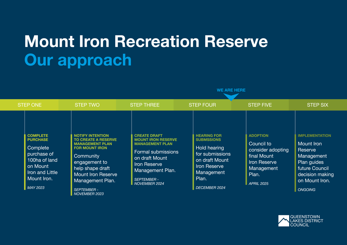
Mount Iron Reserve Management Plan
Council has purchased nearly 100 hectares of land around Mount Iron and Little Mount Iron in Wānaka.
Quick links
About the Mount Iron acquisition
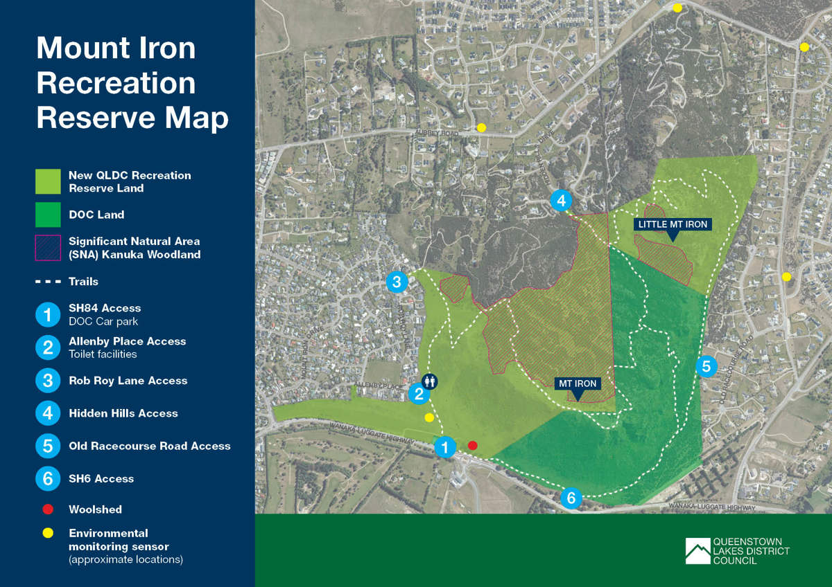
Mount Iron is an iconic landmark in the Upper Clutha. Approximately 2km from the town centre, it offers panoramic views of Wānaka and its surrounds, and is arguably one of the most popular walking tracks in the Upper Clutha with over 180,000 visitors heading up the Mount Iron slopes each year.
In December 2021, Queenstown Lakes District Council reached an agreement to purchase nearly 100ha of land around Mount Iron and Little Mount Iron in Wānaka. While there will be no immediate changes to public use, Council is working closely with the local community, Iwi and the Department of Conservation on plans for Mount Iron’s long-term future, acting as kaitiaki and holding the land as public reserve in perpetuity on its behalf.
What's the latest?
-
The Mount Iron Reserve Management Plan (RMP) has been approved and adopted by Full Council at the 17 April 2025 meeting.
CloseView the final Mount Iron RMP below.
-
A big thank you to all that shared their views on this much loved-landmark - we received over 400 submissions from the community on the draft Mount Iron Reserve Management Plan (RMP)!
You can view the online and written submissions on Let's Talk.
See a summary of the submissions received during the formal consultation below.
Following the public consultation close on 29 November 2024, we had 20 submitters speak to their submissions at a public hearing on 10 December with deliberations being held on 11 December. Listen to a recording here.
All submissions will be considered by the hearing panel and used to make final changes to the RMP for Mount Iron Recreation Reserve.
This plan will then be presented to the Wānaka-Upper Clutha Community Board for recommendation in March and to Full Council for adoption on 17 April 2025.
Close -
The Department of Conservation (DOC) and QLDC have signed a management agreement that applies to the DOC land at Mount Iron from 1 May 2024. It outlines that DOC will continue to undertake all statutory requirements e.g., Regional Pest Management Strategy requirements, reserve closures and management of commercial activities, as set out in the Conservation Act. QLDC has taken on day-to-day management of the site e.g., signage, track maintenance and carpark maintenance.
Close -
We are pleased to share a snapshot summary of the community insights gathered through our early engagement to help inform a draft RMP for Mount Iron. These include a range of comments that came from our workshops and discussions with the community.
You can also read through all the ideas shared on our online interactive map tool, letters from community groups and every piece of information gathered on ‘stickies’, in the raw data, on Let’s Talk.
Close
The Reserve Management Plan process
A Reserve Management Plan (RMP) is a document prepared under the Reserves Act 1977. It sets out a plan for how Council intends to provide for and ensure the use, enjoyment, maintenance, protection, and preservation of a reserve. It details all the rules and regulations to act as a guide for Council officers in making both day-to-day decisions, as well as long-term decisions about how reserves and open spaces under its control are to be used, managed, or developed.
Creation of a Reserve Management Plan for the publicly owned land on Mount Iron and Little Mount Iron is a critical step following its purchase, and will provide ample opportunity for the Upper Clutha community to share how it wants Mount Iron managed in the future.

Public access
All tracks and trails on Mount Iron and Little Mount Iron are now under QLDC management including those on neighbouring Department of Conservation (DOC) land. This follows an agreement with Department of Conservation (DOC) in May 2024 to transfer the day-to-day management of the DOC land to QLDC. This means Council is responsible for the maintenance of these routes including track upkeep, signage and safety notifications to the public.
If you’re planning to explore the area, we ask that you please stick to the public walking tracks and take note of signage identifying privately owned property.
Please note that no new developments will be allowed on the site until the community has had a chance to provide feedback on the future use of Mount Iron Recreation Reserve through the RMP process.
Biking is only allowed around the bottom of Mount Iron between Anderson Road and Old Racecourse Road on shared pathways. No mountain biking or access to the top of Mount Iron by bike is allowed.

Wildfire risk
Please be aware that Mount Iron Reserve is subject to a year-round total fire ban. Since the summer 2023-2024 Council has implemented a Wildfire Reserve Closure Plan for when fire indices reach extreme levels. This is to remove the potential for a fire to happen and ensure people are out of harm's way if it does.
For more information on how Council manages wildfire risk and how we'll let you know if a reserve if closed go to www.qldc.govt.nz/managing-wildfire-risk
Get regular updates
If you'd like to be kept up to date with the latest information relating to Council's management plan for Mount Iron Reserve, we've created a newsletter to share information on the project.
Now that we have new Reserve Management Plan for the Mount Iron and Little Mount Iron these newsletters will come out every three months to share happenings of interest.
Subscribe below to receive this update directly to your inbox!
Newsletters
Stay up-to-date
Sign up to our newsletters and stay up-to-date with the latest news, events & information in the Queenstown Lakes District.