


- Your Council
- News
- Newsletter Archive
- Careers
- Consultations
- Council Documents
- Council Meetings
- Climate Change and Biodiversity
- District Plan
- Elected Members
- Elections
- Major Projects
- Media Centre
- Privacy and official information requests
- Public Notices
- Sister Cities
- Our Strategic Framework
- Fast-track Approvals Act
Environmental Monitoring System
A wildfire in one of our forested reserves could have a devastating effect. As part of our work to reduce the risk and support our communities to prepare for and adapt to the impacts of climate change, we’re working with Spark New Zealand and Attentis Technology to trial cutting-edge technology to monitor conditions within Ben Lomond and Mount Iron Reserves.
Quick links
What's happening?
In early 2024 we installed a network of pole-mounted environmental sensor units. Five were installed around the Ben Lomond Recreation Reserve in Queenstown and a further five were installed around the Mount Iron Recreation Reserve in Wānaka.
The sensors are 8.5m high and provide live micro-climate weather updates, air quality, and visual and thermal imaging which can also assist in early fire detection.
The information gathered by the sensors is transmitted in real-time to allow environmental conditions to be monitored and any fire ignition source to be immediately detected. The information will be available on an app to help people understand and adjust to changing conditions and be alerted if a fire event is detected.
Why it's important
Our climate is changing. We’re likely to see more extreme rainfall and heatwave events which will increase the risk of landslides, flooding, erosion and wildfire adversely impacting our communities.
While we can all take steps to minimise the damage to our environment by reducing emissions, we can’t eliminate all impacts of climate change. We all need to take steps to learn how to adapt and build our resilience in the face of changing weather patterns.
Questions and answers
We’ve provided answers to a number of frequently asked questions below. If you have a question that hasn’t been answered here, please get in touch with us at letstalk@qldc.govt.nz or phone QLDC customer services on 03 441 0499 and we’ll get it answered as quickly as possible.
-
The Attentis network is not a CCTV system as it is only focused on environmental monitoring, not surveillance monitoring.
While the sensors do have cameras, they are not intended to collect images of private residences, only vegetation on Council reserve land.
The only visual images that will be recorded when the system is officially launched will be images that support the monitoring of wildfire risk on Ben Lomond/Mt Iron reserves. Any cameras that do not point at these areas will be permanently shut off, cropped or permanently blurred to prevent any image collection of neighbouring private residences.
Any images captured will only be accessible by Council and partner agencies involved in the project such as FENZ and Otago Civil Defence.
If you have questions or concerns about your privacy please refer to our Privacy Policy, or email privacy@qldc.govt.nz to discuss your concerns with one of our delegated privacy officers.
Close -
The information gathered by the sensors is transmitted in real-time to allow environmental conditions to be monitored and any fire ignition source or other danger to be immediately detected.
This will provide piece of mind to local residents and visitors, help protect the natural environment, wildlife and nearby properties from the risk of fire.
If a fire does break out, the sensors will provide a better understanding of the situation and allow emergency responders to position staff and resources to best respond.
Some of the data collected by the environmental sensors is also publicly accessible through a browser-based online portal.
A mobile app is also available. Registered app users can set up personalised alerts to learn when environmental conditions reach pre-set levels. Both the browser-based version and app may be a valuable tool for asthmatic individuals and those who experience respiratory ailments, providing a mobile platform featuring early warning of airborne pollutants.
Close -
The sensors are 8.5m high, self-powered, unobtrusive, with small footprintsor trenching. The following photo shows an example of a completed installation in Victoria, Australia.
Close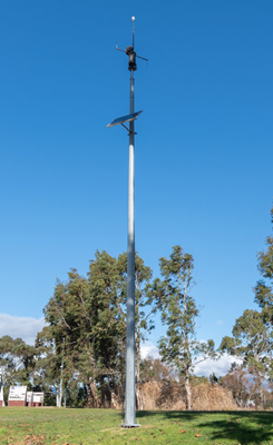
-
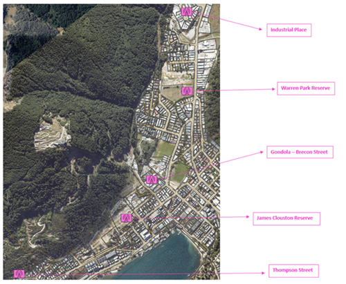
The locations have been determined in consultation with wildfire experts to maximise the efficiency of the network.
Approximate locations of Ben Lomond sensor units:
Approximate locations of Mount Iron sensor units:
Close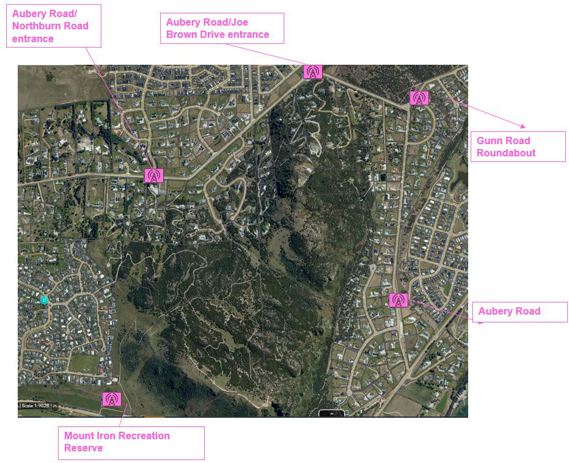
-
The locations at the bottom of each reserve were selected because most fire incidents over the past 10 years have occurred on the urban boundary.
The goal is to prevent a fire starting and/or getting into the reserve, because one it does it may be hard to control due to the steep slopes, large amounts of vegetation and limited access.
Close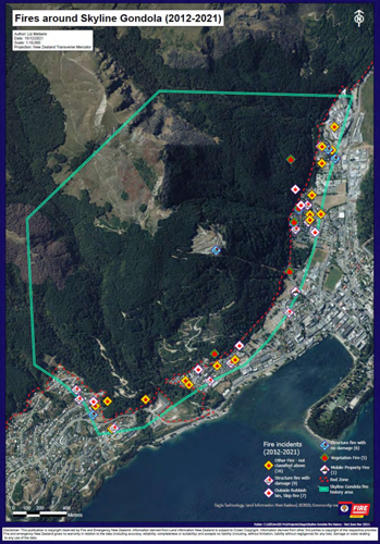
-
The sensors record:
-
Thermal and visual imaging to detect fire starts, re-ignitions, hot spots, fire movements and changes in conditions.
-
Micro-climate information including data on wind speed, wind direction, temperature, relative humidity, barometric pressure and rainfall.
-
Air quality data including levels of particulate matter PM1, PM2.5 and PM10 including pollen, dust, smoke and other particulates that can affect people’s respiratory health.
All data recorded from each location is maintained and analysed to provide both real-time and historic information about the area.
Close -
-
Much like traffic monitoring cameras, the sensor units can take photos, albeit from a high angle and distance. This feature will not be available in sensors which are directed towards urban communities.
Close -
The trial is a collaboration between Queenstown Lakes District Council, Spark New Zealand, and Australian technology firm, Attentis. Fire and Emergency New Zealand (FENZ) has also been closely involved.
Close -
The sensors incorporate multi-communication capabilities, combining licensed radio, unlicensed radio, cellular, satellite and Wi-Fi into a single device to provide redundancy and ensure data delivery. Connectivity is powered by Spark NZ.
Close -
The app can be downloaded from the Apple App store or Google Play Store, just search attentis – smart sensors. It is free to download and use.
Close -
The project costs $198,000 for the five sensors in Queenstown and $195,000 for the five sensors in Wānaka.
There is a $30k annual monitoring and maintenance cost for each site.
Close
What else is underway?
In 2018, Queenstown Lakes District Council set out to understand the threat that wildfires pose to, or from Council administered land. A draft report was prepared, then updated in 2022. The report reviewed 12 public reserves across the district and outlined many recommended interventions across four categories, including: signage and education programmes, creation of fire breaks, legislative changes and early warning systems.
In most reserves, a multifaceted and multi-agency response will be needed to reduce the wildfire risk and many of the recommendations within the report require further investigation by means of a business case. The business case is progressing and will outline estimated costs and the proposed implementation staging of the wildfire recommendations.
In the meantime, QLDC is moving forward with a number of interventions prior to and during the upcoming summer season, in the highest risk areas such as Ben Lomond, Queenstown Hill and Mount Iron Reserves.
This will involve working closely with relevant leaseholders and primarily concentrate on the environmental monitoring/early warning system trial, signage and education programmes, along with a strategy for managing activities in the reserves during higher risk conditions.
For more information on how we are managing the risk of wildfire in our reserves go to www.qldc.govt.nz/managing-the-risk-of-wildfire
Contact us
If you have any further questions, please get in touch with us at
or phone QLDC customer services on 03 441 0499 (Queenstown) or 03 443 0024 (Wānaka).